Hurricane season is heating up—here’s what forecasters want you to know
- Replies 0
As warmer months draw near, coastal communities are once again turning their eyes to the skies—and the sea.
Each year brings a mix of anticipation and anxiety as we await the Atlantic hurricane forecast, and this time, meteorologists are sounding the alarm early.
According to leading researchers, 2025 is shaping up to be one of the more active seasons in recent memory.
From storm names to preparedness tips, here’s a closer look at what experts are predicting—and what it could mean for you.
Of those, nine could strengthen into hurricanes, with four reaching major hurricane status—Category 3 or higher on the Saffir-Simpson scale.

That’s well above the average activity between 1991 and 2020, placing 2025 at 125% of the normal seasonal activity.
Category 3 storms bring sustained winds of 111–129 mph, while Category 4 and 5 hurricanes exceed 130 mph, capable of devastating coastal areas.
Though these temperatures have cooled slightly, they remain elevated—offering prime fuel for storm formation and intensification.
The Atlantic is also under the influence of the El Niño–Southern Oscillation (ENSO) cycle.
Right now, we’re in a weak La Niña phase, but conditions are expected to shift to neutral as summer approaches.
Without the El Niño pattern, which typically suppresses hurricane formation, meteorologists say storm activity could spike.
This year’s slightly lower figure may seem like good news—but with four major hurricanes expected, the risk remains high.
Meteorologist Levi Silvers, one of the experts behind the new forecast, stressed the real-world importance of seasonal outlooks, particularly for those living near the coast.
"It's a noticeable and important difference, because it matters for people along the coastlines whenever we have an above average season," Silvers said.
He also pointed out that storm activity naturally fluctuates, noting, "But I think what's really important to understand here is that the amount of hurricanes that are occurring in the Atlantic and in the Gulf fluctuates a lot from decade to decade. As long as we've been paying attention to hurricanes, we've noticed that they fluctuate a lot from year to year."
A key factor behind this year’s forecast, according to Silvers, is the temperature of the oceans fueling these storms.
“It was super warm, warmer than we've really seen before,” he told CBS News.
He added that while water temperatures have cooled slightly since last year, “they're still warmer than normal, but the temperatures have come down since last time. So that's one of the main factors, why we're forecasting less [activity] than last year, but it's still above average.”
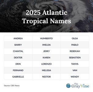
This year, the World Meteorological Organization has designated names like Andrea, Barry, Chantal, Dexter, and Erin for the first few.
If the 21-name list is exhausted, officials will use a supplemental list of storm names already prepared.
Hurricane season officially runs from June 1 to November 30, with peak activity usually seen in August and September.

Agencies like NOAA offer up-to-date guidance, tools, and alerts to help families prepare.
From flashlights and bottled water to digital backups of important documents, small steps now can make a big difference later.

Have you weathered a major storm before? What precautions do you take as hurricane season approaches? Drop your advice, experiences, and questions in the comments below—we’d love to hear how you’re getting ready.
Read more:
Each year brings a mix of anticipation and anxiety as we await the Atlantic hurricane forecast, and this time, meteorologists are sounding the alarm early.
According to leading researchers, 2025 is shaping up to be one of the more active seasons in recent memory.
From storm names to preparedness tips, here’s a closer look at what experts are predicting—and what it could mean for you.
The Forecast Is In: An Above-Average Season on the Horizon
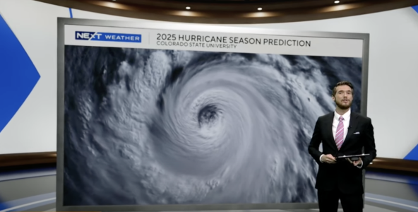
Researchers at Colorado State University’s Tropical Cyclones and Atmospheric Modeling team project a total of 17 named storms this year.Of those, nine could strengthen into hurricanes, with four reaching major hurricane status—Category 3 or higher on the Saffir-Simpson scale.

Researchers at Colorado State University’s Tropical Cyclones and Atmospheric Modeling team project a total of 17 named storms this year. Image source: CBS Miami / YouTube
That’s well above the average activity between 1991 and 2020, placing 2025 at 125% of the normal seasonal activity.
Category 3 storms bring sustained winds of 111–129 mph, while Category 4 and 5 hurricanes exceed 130 mph, capable of devastating coastal areas.
Why This Season Could Be So Intense
A key factor is the unusually warm sea surface temperatures still lingering from last year’s record highs.Though these temperatures have cooled slightly, they remain elevated—offering prime fuel for storm formation and intensification.
The Atlantic is also under the influence of the El Niño–Southern Oscillation (ENSO) cycle.
Right now, we’re in a weak La Niña phase, but conditions are expected to shift to neutral as summer approaches.
Without the El Niño pattern, which typically suppresses hurricane formation, meteorologists say storm activity could spike.
How the Season Compares to 2024
Last year, the forecast suggested 130% of average storm activity.This year’s slightly lower figure may seem like good news—but with four major hurricanes expected, the risk remains high.
Meteorologist Levi Silvers, one of the experts behind the new forecast, stressed the real-world importance of seasonal outlooks, particularly for those living near the coast.
"It's a noticeable and important difference, because it matters for people along the coastlines whenever we have an above average season," Silvers said.
He also pointed out that storm activity naturally fluctuates, noting, "But I think what's really important to understand here is that the amount of hurricanes that are occurring in the Atlantic and in the Gulf fluctuates a lot from decade to decade. As long as we've been paying attention to hurricanes, we've noticed that they fluctuate a lot from year to year."
A key factor behind this year’s forecast, according to Silvers, is the temperature of the oceans fueling these storms.
“It was super warm, warmer than we've really seen before,” he told CBS News.
He added that while water temperatures have cooled slightly since last year, “they're still warmer than normal, but the temperatures have come down since last time. So that's one of the main factors, why we're forecasting less [activity] than last year, but it's still above average.”
What’s in a Name? Meet the 2025 Storm List
Once a tropical storm reaches sustained winds of 39 mph, it earns a name.This year, the World Meteorological Organization has designated names like Andrea, Barry, Chantal, Dexter, and Erin for the first few.
If the 21-name list is exhausted, officials will use a supplemental list of storm names already prepared.
Hurricane season officially runs from June 1 to November 30, with peak activity usually seen in August and September.

What You Can Do Right Now
Now’s the time to review your emergency plan, stock up on essentials, and ensure your home is storm-ready.Agencies like NOAA offer up-to-date guidance, tools, and alerts to help families prepare.
From flashlights and bottled water to digital backups of important documents, small steps now can make a big difference later.
Key Takeaways
- Researchers predict an above-average 2025 Atlantic hurricane season with potentially stronger and more frequent storms than usual.
- Colorado State University experts estimate nine hurricanes, including four major ones, with 17 named storms overall for the season.
- Warm sea surface temperatures are a significant factor in this year's forecast, though slightly cooler compared to the previous year.
- The prediction is somewhat uncertain due to the fluctuating phase of the El Niño-Southern Oscillation, with current weak La Niña conditions possibly transitioning to neutral.
Read more:
Last edited:


