Millions at risk: Is your town next in the path of a dangerous tornado outbreak?
- Replies 0
A menacing system takes aim at the Midwest.
The skies are darkening over the heartland, and millions of Americans are now under threat.
With dangerous winds, massive hail, and strong tornadoes in the forecast, many communities anxiously await what the next hours will bring.
Meteorologists are sounding alarms across northern Iowa, eastern Minnesota, including Minneapolis, and western Wisconsin, where a moderate risk for severe weather is in effect.
Tornado watches are active until 11 p.m. CT Monday, warning forecasters of large, destructive twisters, hail as big as baseballs, and damaging winds.

But the danger zone doesn’t stop there. Parts of Missouri, Nebraska, Kansas, Texas, and Oklahoma are also bracing for impact, with winds possibly roaring up to 75 mph.
Cities like Des Moines and Topeka are squarely in the watch zone, and alerts stretch until 11:59 p.m. CT Monday.
Meanwhile, an enhanced risk of severe weather stretches across a huge swath from Kansas City to Green Bay and Duluth to Sioux Falls.
While a broader slight risk covers areas from west Texas all the way to the western Great Lakes.
Also read: The safest place in America? Find out which US state is practically disaster-proof (and which ones are danger zones!)
This weekend already showcased the storm system’s power.
Over 60 million Americans were under severe weather alerts from Texas to the Great Lakes. On Sunday alone:
The threat continues into Tuesday, with another enhanced risk predicted from central Ohio to western New York. Damaging winds, large hail, and additional tornadoes are likely.
Even regions from western Texas up to northern Vermont will need to stay alert.
Also Read: Are you at stake? Federal agency cuts access to thousands of credit cards amid budget constraints
Compounding the threat, a moderate risk of excessive rainfall could dump up to 7 inches of rain across northern Texas, central Oklahoma, southeast Kansas, and southwestern Missouri, elevating the danger of flash flooding.
Already-saturated soils and swollen streams across Oklahoma and northern Texas will only worsen the flood risk.
Tragically, one person has already died from flash flooding in Oklahoma this weekend, a sobering reminder of the hazards beyond the tornadoes themselves.
Looking further ahead, Wednesday could bring heavy rain and flash flooding across eastern Oklahoma and western Arkansas. Even moderate storms could quickly turn into dangerous flash flood events with the ground already soaked.
Read next: Are you prepared for tornado season? Discover why DOGE’s latest move might affect you!

We're all in this together, and sharing information could save lives. If you have tips or experiences to share about preparing for severe weather, please comment below. Your insights could provide invaluable guidance to others in our community.
The skies are darkening over the heartland, and millions of Americans are now under threat.
With dangerous winds, massive hail, and strong tornadoes in the forecast, many communities anxiously await what the next hours will bring.
Meteorologists are sounding alarms across northern Iowa, eastern Minnesota, including Minneapolis, and western Wisconsin, where a moderate risk for severe weather is in effect.
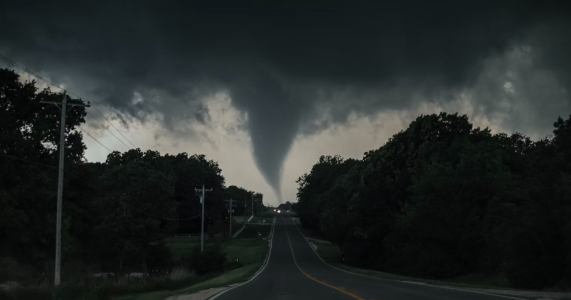
Tornado watches are active until 11 p.m. CT Monday, warning forecasters of large, destructive twisters, hail as big as baseballs, and damaging winds.

Millions across eight states are under a tornado watch, including areas in Iowa, Minnesota, and Wisconsin. Image Source: Greg Johnson / Unsplash
But the danger zone doesn’t stop there. Parts of Missouri, Nebraska, Kansas, Texas, and Oklahoma are also bracing for impact, with winds possibly roaring up to 75 mph.
Cities like Des Moines and Topeka are squarely in the watch zone, and alerts stretch until 11:59 p.m. CT Monday.
Meanwhile, an enhanced risk of severe weather stretches across a huge swath from Kansas City to Green Bay and Duluth to Sioux Falls.
While a broader slight risk covers areas from west Texas all the way to the western Great Lakes.
Also read: The safest place in America? Find out which US state is practically disaster-proof (and which ones are danger zones!)
This weekend already showcased the storm system’s power.
Over 60 million Americans were under severe weather alerts from Texas to the Great Lakes. On Sunday alone:
- 10 tornadoes tore through western Nebraska.
- A tornado near Hyannis, Nebraska derailed a train.
- Hail larger than baseballs pounded several communities.
- Wind gusts of 75 mph slammed into parts of Texas and South Dakota.
The threat continues into Tuesday, with another enhanced risk predicted from central Ohio to western New York. Damaging winds, large hail, and additional tornadoes are likely.
Even regions from western Texas up to northern Vermont will need to stay alert.
Also Read: Are you at stake? Federal agency cuts access to thousands of credit cards amid budget constraints
Compounding the threat, a moderate risk of excessive rainfall could dump up to 7 inches of rain across northern Texas, central Oklahoma, southeast Kansas, and southwestern Missouri, elevating the danger of flash flooding.
Already-saturated soils and swollen streams across Oklahoma and northern Texas will only worsen the flood risk.
Tragically, one person has already died from flash flooding in Oklahoma this weekend, a sobering reminder of the hazards beyond the tornadoes themselves.
Looking further ahead, Wednesday could bring heavy rain and flash flooding across eastern Oklahoma and western Arkansas. Even moderate storms could quickly turn into dangerous flash flood events with the ground already soaked.
Read next: Are you prepared for tornado season? Discover why DOGE’s latest move might affect you!
Key Takeaways
- Millions across eight states are under a tornado watch, including areas in Iowa, Minnesota, and Wisconsin.
- Severe threats include strong tornadoes, massive hail, and winds up to 75 mph, continuing into late Monday night.
- Over 60 million people were impacted by the weekend's severe weather, with confirmed tornadoes and catastrophic damage in parts of Nebraska and Texas.
- Risks persist through Tuesday and Wednesday, with flooding threats intensifying in Oklahoma, Texas, and Arkansas due to excessive rainfall.


